
Fájl:Mwamongu water source.jpg

Eredeti fájl (946 × 768 képpont, fájlméret: 344 KB, MIME-típus: image/jpeg)
| Leírás |
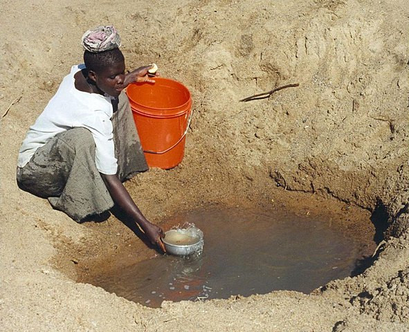
English: Mwamanongu Village water source, Tanzania. "In Meatu district, Shinyanga region, Tanzania, water most often comes from open holes dug in the sand of dry riverbeds, and it is invariably contaminated." .
Français : Point d'eau du village de Mwamanongu, en Tanzanie. "Dans le district de Meatu (région de Shinyanga, Tanzanie), L'eau provient le plus souvent de trous creusés dans le sable de lits de rivières asséchées. Elle est systématiquement contaminée." |
||
| Dátum | |||
| Forrás |
http://solarcooking.wikia.com/wiki/Image:Mwamongu_water_source.jpg, |
||
| Szerző | Bob Metcalf | ||
| Engedély (Fájl újrafelhasználása) |
|
| Fényképező elhelyezkedése | | További képek erről a helyről: OpenStreetMap |
|---|
Location note from author: If one goes north from the city of Tabora, follow it to Shinyanga. Shinyanga town is the administrative location of the Shinyanga Region, which includes several districts, Meatu District being one of them. From Shinyanga, go east to find the town of Mhunze, which I think is what I know as Mwanhuze, the District headquarters. It was from Mhunze that we took a Land Rover a bit northwest, I think, perhaps 15 km, to reach Mwamanongu. The driver knew how to get to these villages, but there were no road signs anywhere, nor any landmarks on the flat land, and the 'road' was just a path, often in lousy condition for the rare vehicle that would use it.
Editor's note: Mwanhuze and Mwamanongu are wards in en:Meatu District.[1] Meatu is a trapezoidal region that borders the western end of Lake Eyasi and extends roughly 70 km to the northwest.[2] Mhunze is a ward in en:Bariadi District. Walter Siegmund (talk) 05:02, 14 January 2008 (UTC)

|
Ez a kép elbírálásra került a Értékes kép irányelvek alapján, amikor is a Commons egyik legértékesebb képévé nyilvánították az alábbi területen: Primitive water supply. Megnézheted a jelölését a Commons:Valued image candidates/Mwamongu water source.jpg lapon. |
Fájltörténet
Kattints egy időpontra, hogy a fájl akkori állapotát láthasd.
| Dátum/idő | Bélyegkép | Felbontás | Feltöltő | Megjegyzés | |
|---|---|---|---|---|---|
| aktuális | 2008. január 13., 01:39 | | 946 × 768 (344 KB) | Wsiegmund | PE; cropped white borders |
| 2008. január 13., 01:38 |  | 1 024 × 768 (149 KB) | Wsiegmund | Upload slightly larger version | |
| 2008. január 12., 16:58 |  | 944 × 704 (85 KB) | Wsiegmund | {{Information |Description=Mwamongu Village water source, Tanzania |Source=Wikia:c:solarcooking:Image:Mwamongu_water_source.jpg |Date=2006-06-06 |Author=Bob Metcalf |Permission={{PD-author|Bob Metcalf}} |other_versions= }} |
Fájlhasználat
Az alábbi lapok használják ezt a fájlt:
Globális fájlhasználat
A következő wikik használják ezt a fájlt:
- Használata itt: af.wikipedia.org
- Használata itt: ar.wikipedia.org
- Használata itt: ca.wikipedia.org
- Használata itt: da.wikipedia.org
- Használata itt: de.wikipedia.org
- Használata itt: de.wikibooks.org
- Használata itt: de.wiktionary.org
- Használata itt: el.wikipedia.org
- Használata itt: en.wikipedia.org
- Használata itt: en.wikibooks.org
- Használata itt: en.wikiversity.org
- Használata itt: en.wiktionary.org
- Használata itt: es.wikipedia.org
- Használata itt: eu.wikipedia.org
- Használata itt: fi.wikipedia.org
- Használata itt: fr.wikipedia.org
- Használata itt: fr.wiktionary.org
- Használata itt: ga.wikipedia.org
- Használata itt: gur.wikipedia.org
- Használata itt: he.wikipedia.org
- Használata itt: hi.wikipedia.org
- Használata itt: id.wikipedia.org
- Használata itt: ig.wikipedia.org
- Használata itt: io.wiktionary.org
- Használata itt: it.wikipedia.org
- Használata itt: ja.wikipedia.org
A fájl globális használatának megtekintése